You’re reading this online, your data likely pinging through a server farm hundreds of miles away, a process we casually call “the cloud.” But this ethereal term masks a brute physical reality. The internet is not in the sky; it’s at the bottom of the ocean. Roughly 99% of all international data—emails, financial transactions, video calls, military communications—travels not through satellites, but through a vast, submerged network of fiber optic cables that form the true backbone of our connected world.
This hidden geography of the internet is one of the most critical and contested landscapes of the 21st century. The placement, ownership, and security of these cables are central to modern geopolitics, shaping everything from economic power to espionage.
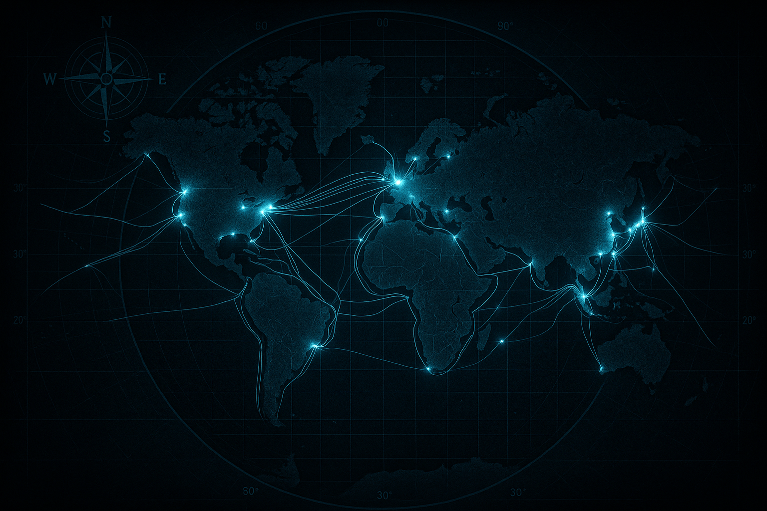
The Global Nervous System: Mapping the Digital Arteries
Imagine over 550 active and planned cables, totaling more than 1.4 million kilometers, crisscrossing the ocean floor. These are the world’s digital arteries. A modern undersea cable is a marvel of engineering, typically no thicker than a garden hose. At its core are hair-thin strands of pure glass, through which data travels as pulses of light. These fragile fibers are encased in layers of copper, steel wires, and polyethylene for protection.
While this network is global, it is not uniform. Data, like water, follows the path of least resistance, creating critical geographical choke points where a huge portion of the world’s information is concentrated. Disruptions in these narrow corridors can have catastrophic consequences.
- The Red Sea: Connecting Europe and Asia, the narrow Bab el-Mandeb Strait and the Suez Canal form perhaps the most vital digital choke point on Earth. A huge number of cables, including the massive SEA-ME-WE (South East Asia-Middle East-Western Europe) systems, are funneled through this passage. Egypt, controlling the land route between the Mediterranean and the Red Sea, holds immense geographic and economic power as a gatekeeper of global data. The recent severing of four cables in this region, allegedly by Houthi rebels in early 2024, highlighted its extreme vulnerability.
- The Strait of Malacca: This narrow channel between the Malay Peninsula and the Indonesian island of Sumatra is the primary shipping lane between the Indian and Pacific Oceans. It is also packed with cables connecting economic powerhouses like Singapore, India, and China to the rest of the world.
- The Luzon Strait: Located between Taiwan and the Philippines, this strait is a critical junction for data traffic connecting Hong Kong, Taiwan, Japan, and South Korea. Its location within the fiercely contested South China Sea makes it a point of significant geopolitical tension.
- The Transatlantic Corridor: The historical heart of the internet, this route connects North America and Europe. Key landing cities like Virginia Beach, USA; Bude, UK; and Marseille, France act as massive gateways where dozens of high-capacity cables come ashore, making them some of the most connected places on the planet.
The Geopolitics of Landing Rights
Where a cable makes landfall is not a matter of simple convenience; it is a profound political statement. A landing station gives a country regulatory control over the data that flows through it, creating opportunities for surveillance and economic leverage.
Historically, cables were owned by consortiums of state-owned telecom companies. Today, a new power has emerged: Big Tech. Companies like Google, Meta (Facebook), Amazon, and Microsoft are now the primary financiers and owners of new undersea cables. Google’s private “Equiano” cable runs down the west coast of Africa, and its “Dunant” cable crosses the Atlantic. This shift moves control over critical infrastructure from public-private partnerships to private corporations, changing the dynamics of digital sovereignty.
This new era is defined by the US-China tech rivalry. The US government has actively intervened to block or reroute cables that would directly connect US territory with China and Hong Kong. In a landmark case, the Pacific Light Cable Network (PLCN), backed by Google and Meta, was originally designed to link the US to Hong Kong. Citing national security concerns that China could access sensitive US data, Washington only approved the segments connecting to Taiwan and the Philippines, forcing the Hong Kong link to be abandoned. This was a clear message: data routes must now conform to geopolitical alliances.
In response, China is building its own global internet infrastructure under the banner of its “Digital Silk Road.” The PEACE (Pakistan & East Africa Connecting Europe) cable is a prime example. Snaking from China to Pakistan, down the Horn of Africa, and through the Red Sea to France, it strategically bypasses US-dominated routes and connects nations within Beijing’s sphere of influence. This risks bifurcating the internet, creating a system where data flows are increasingly segregated along political lines.
Achilles’ Heel: Vulnerability and Espionage
The concentration of global data into a few physical strands makes the entire system surprisingly fragile. Vulnerabilities range from the accidental to the deeply malicious.
Most cable faults are caused by mundane accidents like fishing trawlers and ship anchors. But natural disasters can also wreak havoc. In 2006, the Hengchun earthquake off the coast of Taiwan severed multiple cables, disrupting internet and financial services across Asia for weeks.
The more sinister threat is deliberate sabotage. In a conflict, a state actor could sever an adversary’s cables, effectively cutting them off from the global economy and crippling their military command and control. Western intelligence agencies have repeatedly warned of Russian submarines and “research” ships, like the spy vessel Yantar, operating suspiciously close to key transatlantic cables. For NATO, the security of this undersea infrastructure is now a top-tier defense priority.
Beyond cutting, there is the threat of tapping. This is not new. During the Cold War, the US Navy’s Operation Ivy Bells involved placing a sophisticated listening device on a Soviet undersea cable. Today, the stakes are infinitely higher. The Edward Snowden revelations exposed how the NSA (via PRISM) and Britain’s GCHQ (via TEMPORA) accessed staggering amounts of data by tapping directly into fiber optic cables, often at the landing stations where data is temporarily unencrypted. This makes the physical geography of places like Bude, Cornwall—a quiet coastal town and major GCHQ surveillance site—a front line in modern espionage.
New Frontiers: The Race for the Arctic
As climate change melts the Arctic ice, a new, shorter data route connecting Europe and Asia is becoming a geographical and political reality. Projects like the “Far North Fiber” aim to lay cables across the top of the world, bypassing the Suez Canal choke point entirely.
This emerging route has triggered a new “Great Game” in the Arctic. Russia sees the route as a way to exert influence and generate transit fees, while China views it as a crucial leg of its Polar Silk Road. Meanwhile, the US, Canada, and their European allies are scrambling to ensure this new digital artery doesn’t fall under the control of their rivals. The geopolitics of undersea cables is expanding to the last frontiers of the planet.
The invisible network that powers our lives is etched onto the very geography of our planet—its seabeds, its choke points, and its political fault lines. To understand the map of these cables is to understand the flow of power, wealth, and conflict in the 21st century.