Imagine two great rivers flowing side-by-side, separated for millennia by a ridge of high ground. For generations, they follow their own distinct paths to the sea, carving valleys and nourishing the lands around them. Then, over a geologic timescale so slow it’s imperceptible to humans, a dramatic heist takes place. One river, more aggressive and powerful, chews its way through the dividing ridge and, in a final act of hydro-larceny, steals the headwaters of its neighbor. The victim is left beheaded and weakened, and the landscape is permanently, irrevocably changed. This is not fiction; this is stream capture, one of the most fascinating and powerful processes in physical geography.
Also known as river piracy, stream capture is a testament to the fact that the Earth’s surface is not a static map but a dynamic battleground where water, rock, and time are the primary combatants. Let’s dive into how this grand theft happens and where we can see its incredible aftermath etched into our world.
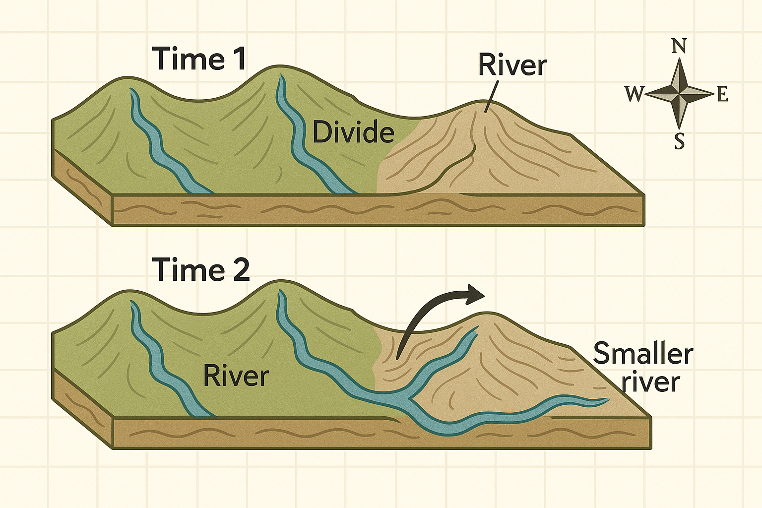
The Anatomy of a River Heist
A successful river capture isn’t a random event. It’s the result of one river system having a distinct advantage over another. The “aggressor” stream succeeds by exploiting weaknesses and leveraging its own strengths. The primary mechanism behind this is a process called headward erosion.
While we normally think of rivers eroding downwards (deepening their channel) or sideways (widening their valley), they also erode backward at their source. Through rainfall, spring sapping, and gullying, a river channel slowly but surely lengthens upstream, eating its way back into the landscape. When a river undergoing aggressive headward erosion is situated next to another, less vigorous river, the stage is set for a capture.
Several factors can give a river the upper hand:
- A Steeper Gradient: A river flowing down a steeper slope has more gravitational energy. Its water moves faster, giving it greater power to cut through rock and transport sediment. This allows it to erode headward more quickly than a neighboring river on a gentler slope.
- Softer Bedrock: A river flowing over softer, less-resistant rock (like shale or sandstone) will carve its valley much faster than one trying to cut through hard, crystalline rock (like granite or gneiss).
- Greater Discharge: A river in a region with higher rainfall will naturally have more water. More volume means more power to erode and lengthen its channel.
The “pirate” stream uses one or more of these advantages to push its headwaters back until it breaches the watershed—the ridge of high land, also known as a drainage divide—that separates it from its neighbor. Once it intersects the channel of the other river, the capture is complete. Water, always following the path of least resistance, will abandon its old, higher-elevation course and pour into the newly available, steeper, and more efficient channel of the captor stream.
The Evidence Left Behind: A Changed Landscape
Like any good heist, river capture leaves behind a trail of evidence. Geomorphologists can read the landscape like detectives, identifying the tell-tale signs of a long-ago piracy event.
The Elbow of Capture
This is perhaps the most dramatic clue. The captor stream, now combined with the upper portion of its victim, often displays a sharp, high-angle turn in its course. This unnatural-looking bend, or elbow of capture, marks the exact point where the pirate stream broke through the divide and diverted the flow. It looks awkward because it is—it’s the suture point of two once-separate river systems.
The Underfit Stream
What happens to the victim? The lower portion of the captured river is suddenly cut off from its source, its headwaters now flowing in a different direction. This “beheaded” stream has a drastically reduced flow. What’s left is a small, weak river or creek flowing in a valley that is clearly far too large for it. This is called an underfit stream. Seeing a tiny creek meandering through a massive, U-shaped valley is a classic sign that a much larger river once flowed there.
The Wind Gap
The abandoned valley where the captured river once flowed over the divide is now left high and dry. This empty notch in the ridge is known as a wind gap. No longer carrying water, it’s a silent monument to the river that once was. Today, these gaps are often convenient routes for roads and railways, like a pre-made pass through a mountain ridge.
Case Files: Famous River Captures Around the World
River piracy has reshaped continents. Here are a few famous examples:
The Shenandoah River, USA: In Virginia’s Blue Ridge Mountains, you can see a textbook case of stream piracy. The energetic, steep-gradient Shenandoah River eroded westward through the mountains, capturing the headwaters of several creeks, including Beaverdam Creek. The result is a sharp elbow of capture near Snickers Gap. And what is Snickers Gap? It’s the wind gap—the dry, abandoned valley left behind by Beaverdam Creek, now used by Virginia State Route 7.
The River Teays & Ohio River, North America: This was a capture on a continental scale. Before the Ice Ages, the major river of the central United States was not the Ohio, but the Teays, which flowed northwest from the Appalachians across Ohio, Indiana, and Illinois. When massive glaciers advanced from the north, they dammed the Teays, creating a vast lake. The water eventually found a new, lower outlet to the south, spilling over divides and carving a new path. This new path became the modern Ohio River, which captured the entire upper drainage basin of the ancient Teays. The original Teays valley is now buried under glacial sediment, but its course can be traced by geologists and well-drillers.
The Meuse & Moselle Rivers, Europe: In northeastern France, the River Moselle once flowed north to join the Meuse. However, a tributary of the Rhine, with a steeper gradient and more erosive power, worked its way headward and captured the Moselle near the city of Toul. Today, the Moselle takes a sharp turn at Toul—a classic elbow of capture—and flows eastward to join the Rhine, leaving its former northern valley as an underfit stream.
The Human Connection
While it unfolds over geologic time, river capture has profound implications for human geography. A capture can entirely redistribute water resources, turning a once-fertile valley arid and potentially increasing flood risk downstream in the newly enlarged captor river’s valley. Early settlements, which often grew along reliable water sources, could find their lifeblood diverted away.
Today, understanding the dynamics of erosion helps us manage landscapes, plan infrastructure, and predict geological hazards like landslides, which are common in the steep, headward-eroding zones that drive river capture. By reading the clues left by ancient river pirates, we not only reconstruct the past but also gain a deeper appreciation for the immense and relentless forces that continue to shape our planet’s surface.
The next time you drive through a gap in a ridge or see a small creek in an oversized valley, take a moment. You might be looking at the scene of a crime—a grand theft that happened in slow motion, written into the very bones of the Earth.