This isn’t a political border marked by posts and guards, but a profound biological boundary etched into the planet by forces of deep time and geology. It separates two of the world’s great ecozones: the Indomalayan realm of Asia and the transitional zone of Wallacea, which leads to the Australasian realm. So, why do the animals on one side of this watery divide seem to have almost no relation to their neighbors just a few miles away?
The Explorer and His Epiphany
To understand the line, we must first meet the man who drew it: Alfred Russel Wallace. Often overshadowed by his contemporary, Charles Darwin, Wallace was one of the 19th century’s most brilliant naturalists and explorers. Between 1854 and 1862, he traveled over 14,000 miles through the Malay Archipelago (present-day Indonesia, Malaysia, Singapore, and Timor-Leste), collecting an astonishing 125,660 specimens.
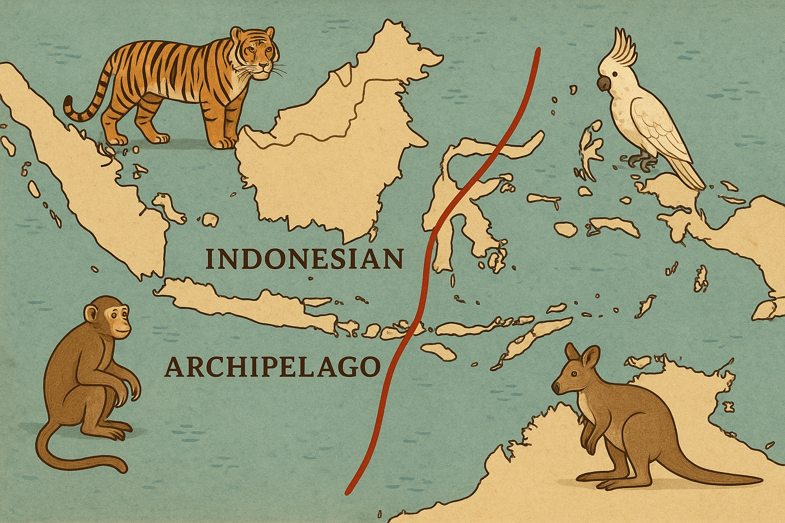
It was during these travels that Wallace, a meticulous observer, noticed a startling pattern. On the western islands like Borneo, Sumatra, and Java, he found the familiar fauna of mainland Asia.
- Tigers
- Rhinoceroses
- Elephants
- Orangutans and other monkeys
- Woodpeckers and barbets
But when he crossed the deep channel between Bali and Lombok, and between Borneo and Sulawesi, this entire menagerie vanished. In its place, he found a completely different set of creatures, ones that bore a striking resemblance to the wildlife of Australia.
- Marsupials like the cuscus
- Unique birds like cockatoos, honeyeaters, and megapodes (mound-building birds)
- A distinct lack of the large placental mammals found just to the west
Wallace was astounded. “I believe the western and eastern islands of the Archipelago belong to regions that are as radically distinct as South America and Africa”, he wrote. In 1859, he sketched a line on the map, proposing a faunal boundary that snaked its way between these islands. This became known as the Wallace Line.
The Geographic Key: Deep Water and Ancient Continents
The solution to Wallace’s puzzle lies not on the surface of the water, but deep beneath it, in the realm of physical geography and plate tectonics. The answer is all about sea levels and ancient land bridges.
During the Pleistocene epoch, better known as the Ice Ages, vast quantities of Earth’s water were locked up in polar ice caps. This caused global sea levels to drop by as much as 120 meters (nearly 400 feet). This dramatic drop exposed huge tracts of the continental shelf.
To the west of the Wallace line lies the Sunda Shelf. When sea levels were low, this shelf became dry land, creating a massive land bridge called “Sundaland” that connected the islands of Sumatra, Java, and Borneo to mainland Southeast Asia. This allowed Asian animals—from tigers to orangutans—to simply walk to the islands that are now separated by sea. Bali was the easternmost tip of this ancient peninsula.
To the east of the line, Australia and New Guinea were similarly connected by a land bridge on the Sahul Shelf, forming a supercontinent called “Sahul.” This allowed for the free movement of marsupials and other Australasian fauna across that region.
The crucial feature of the Wallace Line is that it traces the path of a deep-water trench, including the Lombok Strait. This strait is over 300 meters deep. Even when sea levels were at their lowest, this channel remained a formidable, deep-water barrier. It was too wide and the currents too strong for most terrestrial mammals to cross. While birds, flying insects, and some rafting reptiles or amphibians could make the journey, larger land animals could not. For millions of years, the two populations evolved in near-total isolation from one another.
Wallacea: The Transitional Zone
Geography is rarely simple, and the Wallace Line is not a razor-sharp division. Subsequent scientists noted that the transition from Asian to Australian fauna is more gradual. The region between Wallace’s original line and the shores of New Guinea is now known as Wallacea, a unique transitional zone and a biodiversity hotspot in its own right.
Wallacea itself is a complex archipelago of islands—including Sulawesi, Lombok, Flores, and the Moluccas—that were never connected to either continental landmass. Their isolation has made them a natural laboratory for evolution, resulting in an extraordinary number of endemic species found nowhere else on Earth. Famous inhabitants include:
- The Komodo Dragon: The world’s largest lizard, found on Komodo, Flores, and a few neighboring islands.
- The Babirusa: A bizarre “pig-deer” with tusks that curve back towards its own skull, found on Sulawesi.
- The Anoa: The world’s smallest buffalo, also endemic to Sulawesi.
Scientists have proposed other boundaries within this zone, like Weber’s Line and Lydekker’s Line, to more accurately map the point where Australian fauna begins to outnumber Asian fauna. But Wallace’s original observation remains the most fundamental.
Human Geography and Modern Importance
The Wallace Line didn’t just stop animals; it also influenced the migration of early humans, though they proved more adept at crossing the water. The discovery of Homo floresiensis, the so-called “Hobbit”, on the island of Flores—deep within Wallacea—proves that ancient hominins managed to make the crossing, likely on simple rafts, hundreds of thousands of years ago.
Today, the Wallace Line has profound implications for conservation and human activity. The unique, isolated ecosystems of Wallacea are incredibly vulnerable to deforestation, climate change, and invasive species. Cities like Denpasar in Bali serve as gateways to the Asian ecological realm, while Makassar in Sulawesi is a hub for exploring the strange new world of Wallacea. The line drives tourism, with travelers flocking to see Komodo dragons or dive in the biologically rich waters of Raja Ampat, all thanks to the deep-sea trenches that Wallace so brilliantly identified as a barrier.
Ultimately, the Wallace Line is a powerful reminder that the map of life is drawn not by us, but by immense geological forces. It is a testament to how an invisible feature—the depth of the ocean floor—can create one of the most visible and dramatic divides in the natural world.