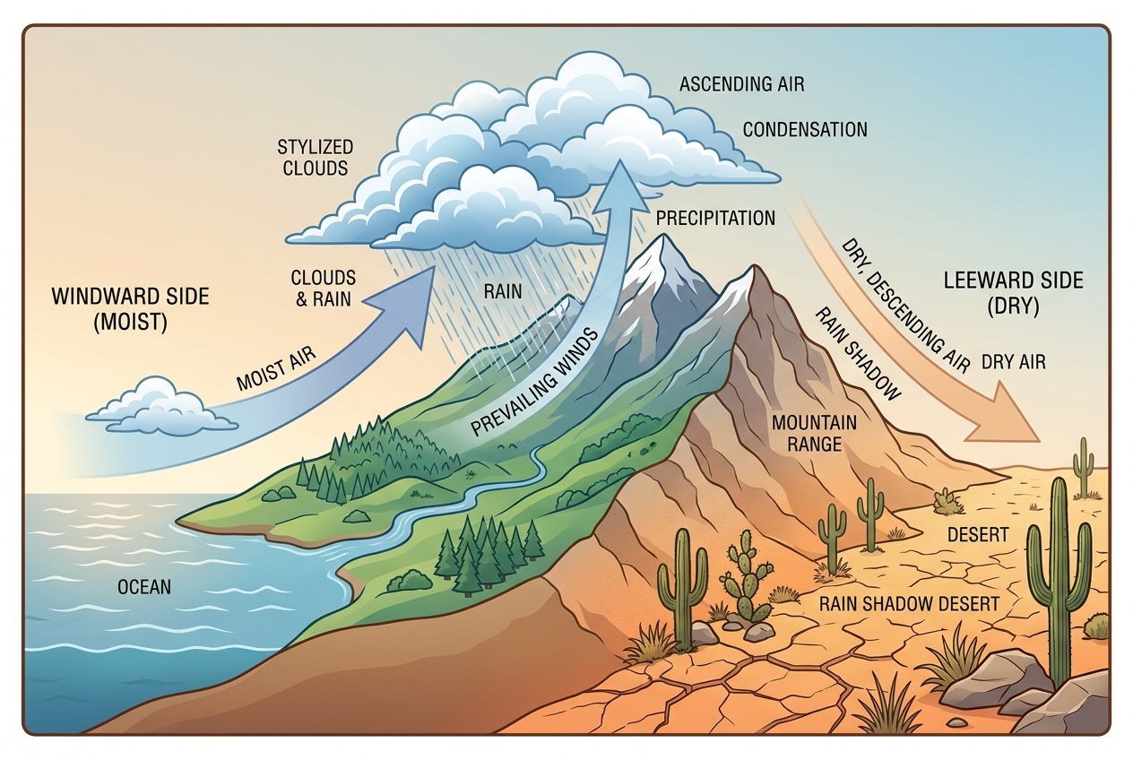
Stand on the western slopes of the Sierra Nevada in California and you’ll walk through lush forests of giant sequoias, fed by some of the heaviest snowfall in North America. Drive just a hundred kilometers east, and you’ll find yourself in Death Valley—the hottest, driest place on the continent, where years can pass without meaningful rain. The culprit behind this dramatic transformation? The mountains themselves. Welcome to the world of rain shadows, one of geography’s most striking examples of how landforms shape climate.
The Physics of a Rain Shadow: Orographic Lift Explained
To understand rain shadows, you first need to understand what happens when moving air meets a mountain. When moist air blowing off an ocean encounters a mountain range, it has nowhere to go but up. This forced ascent is called orographic lift, and it sets off a chain reaction with dramatic consequences.
As air rises, atmospheric pressure decreases, and the air expands and cools—roughly 6 to 10 degrees Celsius for every 1,000 meters of elevation gain. Cool air holds less moisture than warm air, so as the temperature drops, water vapor condenses into clouds and eventually falls as rain or snow. This is why the windward slopes of mountains—the sides facing the prevailing winds—are often remarkably wet and green.
But here’s the critical part: by the time that air crests the summit and begins descending the other side, it has been wrung nearly dry. As it sinks down the leeward slope, the air compresses and warms, which actually increases its capacity to hold moisture. Instead of releasing rain, this warm, dry air soaks up whatever moisture it encounters, desiccating the landscape below. The result is a rain shadow: a zone of persistent aridity on the sheltered side of the mountains.
The process can be summarized in four steps:
- Ascent: Moist air is forced up the windward slope
- Condensation: Cooling air releases moisture as precipitation
- Descent: Dry air sinks down the leeward slope
- Warming: Compression heats the air, further drying the land below
The Atacama: The Driest Place on Earth
Nowhere illustrates the rain shadow effect more powerfully than Chile’s Atacama Desert. Wedged between the Pacific Ocean and the towering Andes, the Atacama receives an average of less than 15 millimeters of rain per year—and some weather stations there have never recorded rainfall at all. Parts of the desert are so barren that NASA uses them to test Mars rovers.
The Atacama is actually a victim of a double rain shadow. To the east, the Andes—reaching heights above 6,000 meters—block moist air flowing from the Amazon Basin. To the west, the smaller Chilean Coast Range intercepts what little moisture drifts in from the Pacific, which is itself chilled by the cold Humboldt Current, suppressing evaporation and cloud formation. Trapped between these barriers, the Atacama has remained hyper-arid for millions of years, making it one of the oldest deserts on the planet.
Remarkably, people have lived here for millennia. Cities like Antofagasta and Calama thrive on mining—the Atacama holds some of the world’s richest copper and lithium deposits—while ancient cultures like the Atacameño people developed ingenious irrigation systems fed by Andean snowmelt.
Death Valley and the American West
North America offers its own textbook example. Storms rolling in from the Pacific slam into California’s Sierra Nevada, dumping enormous quantities of snow on the western slopes—the town of Tamarack once recorded nearly 10 meters of snow in a single month. But east of the crest, precipitation plummets.
Death Valley, sitting in the shadow of not one but four successive mountain ranges, receives barely 50 millimeters of rain annually. Descending air warms as it sinks into the valley, which lies 86 meters below sea level, helping produce the highest air temperature ever reliably recorded on Earth: 56.7°C (134°F) at Furnace Creek in 1913.
The rain shadow of the Sierra Nevada and the Cascade Range extends far beyond Death Valley. It shapes the entire Great Basin, the sagebrush steppes of Nevada, and the arid interior of Oregon and Washington—where the lush, rain-soaked forests of Seattle give way, just past the Cascades, to the dry wheat country around Yakima and Spokane.
Rain Shadows Around the World
Once you know what to look for, rain shadows appear on every continent:
- The Gobi Desert (Mongolia and China): The Himalayas, the tallest mountains on Earth, block moisture from the Indian Ocean monsoon, leaving Central Asia parched. The contrast is stunning: Cherrapunji, India, on the windward side, is one of the wettest places on Earth, while the Tibetan Plateau and Gobi beyond are starkly dry.
- Patagonia (Argentina): The southern Andes intercept the fierce westerly winds of the “Roaring Forties.” Chilean Patagonia is drenched in rain and cloaked in temperate rainforest; Argentine Patagonia, just across the divide, is a windswept semi-desert of scrub and gravel.
- The Canterbury Plains (New Zealand): The Southern Alps wring moisture from Tasman Sea winds—the west coast can receive over 10 meters of rain a year—while the eastern plains around Christchurch are dry enough to require extensive irrigation for agriculture.
- Judean Desert (Israel and the West Bank): The Judean Hills capture Mediterranean moisture, leaving the land descending toward the Dead Sea remarkably arid despite being only kilometers from green highlands.
Two Climates, One Ridge: The Human Dimension
Rain shadows don’t just shape landscapes—they shape human societies. Where you find a sharp windward-leeward divide, you often find profoundly different economies, settlement patterns, and ways of life on either side.
In Washington State, the wet west supports timber, dense cities, and tech industries, while the dry east depends on irrigated agriculture drawing from the Columbia River. In South America, Chile and Argentina developed distinct agricultural traditions partly because the Andes deal them completely different climatic hands. And in Hawaii, the windward side of the Big Island around Hilo receives over 3,000 millimeters of rain annually, while the leeward Kona coast—prime resort territory—basks in near-constant sunshine just a short drive away.
Rain shadow regions also face distinct challenges. Water scarcity forces communities to rely on rivers fed by mountain snowpack, aquifers, or long-distance aqueducts—resources increasingly strained by climate change. As warming reduces mountain snowfall in ranges like the Sierra Nevada and the Andes, the leeward communities that depend on that meltwater face an uncertain future.
Reading the Landscape
The next time you look at a map of the world’s deserts, notice how many of them huddle behind mountain walls: the Atacama behind the Andes, the Gobi behind the Himalayas, the Great Basin behind the Sierra Nevada. It’s a pattern written across the globe by a simple physical principle—air rises, cools, and rains; air sinks, warms, and dries.
Mountains, in other words, are more than scenery. They are climate machines, harvesting moisture on one side and casting deserts on the other. One ridge, two worlds—and a powerful reminder that in geography, elevation is destiny.