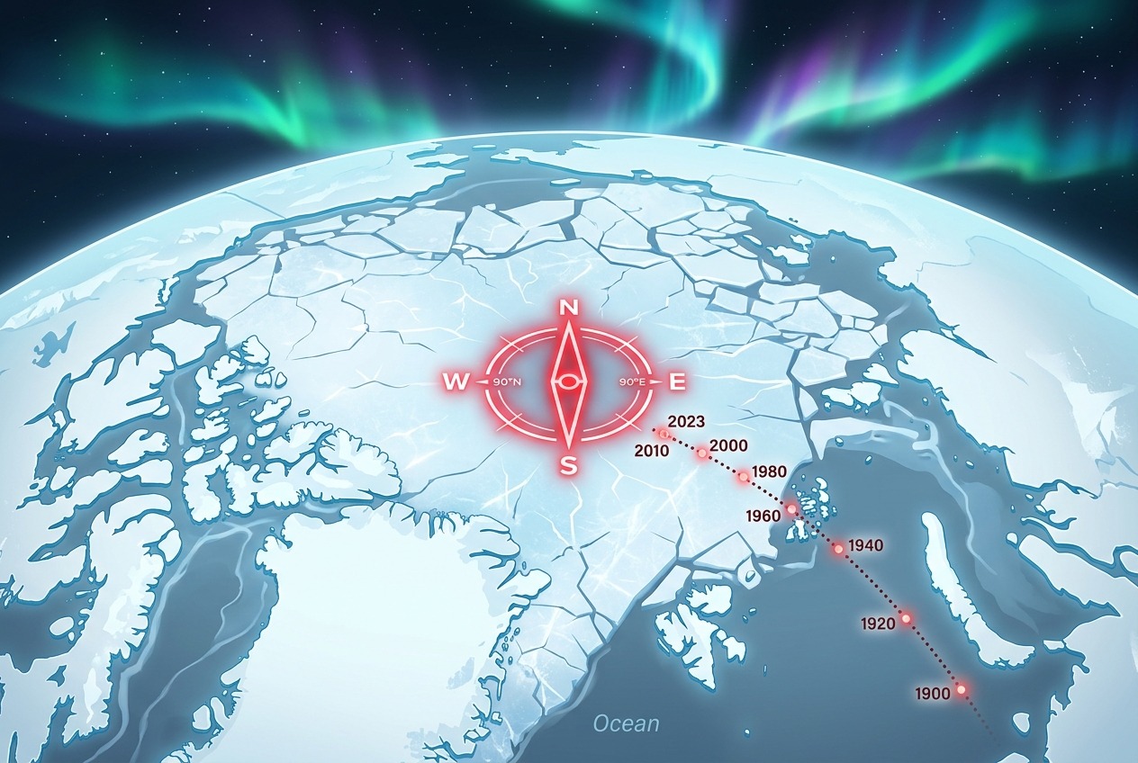
Imagine waking up one morning to discover that north—the reliable, unchanging north you’ve trusted your entire life—has quietly packed its bags and moved hundreds of kilometers. That’s not science fiction. It’s happening right now, deep beneath the Arctic ice, and it’s forcing scientists, pilots, and navigators around the world to scramble to keep up.
The magnetic north pole, that invisible point where Earth’s magnetic field plunges vertically into the ground, has been on a remarkable journey. After spending centuries meandering slowly through the Canadian Arctic, it has accelerated dramatically, racing across the Arctic Ocean toward Siberia at speeds that have stunned geophysicists. This wandering pole isn’t just a scientific curiosity—it affects everything from transatlantic flights to the compass app on your smartphone.
Two Norths: A Geographic Distinction That Matters
Before diving into the pole’s great migration, it’s worth clarifying a common confusion. Earth actually has two north poles, and they are not in the same place.
- Geographic North Pole: This is the fixed point where Earth’s rotational axis meets the surface, located at 90 degrees north latitude in the middle of the Arctic Ocean. It doesn’t move (at least not meaningfully on human timescales).
- Magnetic North Pole: This is where the planet’s magnetic field lines point straight down. It’s a product of the churning molten iron in Earth’s outer core—and unlike its geographic cousin, it wanders constantly.
When you hold a compass, the needle points toward magnetic north, not geographic north. The angular difference between the two, known as magnetic declination, varies depending on where you are on the planet. In some places, the difference is negligible. In others—particularly at high latitudes—it can exceed 20 degrees, enough to send a ship or aircraft wildly off course if uncorrected.
A Journey from Canada to Siberia
When British explorer James Clark Ross first located the magnetic north pole in 1831, it sat on the Boothia Peninsula in what is now Nunavut, Canada. For most of the 20th century, the pole drifted lazily northward at around 10 to 15 kilometers per year—slow enough that navigational charts needed only occasional updates.
Then, in the 1990s, something changed. The pole’s speed surged dramatically, peaking at roughly 50 to 55 kilometers per year in the early 2000s. By 2017, it had crossed the international date line and left Canadian territory behind, heading decisively toward the Siberian coast of Russia. Today, the pole sits in the central Arctic Ocean, closer to Russia than to Canada—a geopolitically symbolic shift that has captured public imagination.
To put this in perspective: in the span of a single human lifetime, the magnetic north pole has traveled well over 1,000 kilometers. That’s roughly the distance from London to Berlin, or from New York City to Chicago.
What’s Driving the Drift? The Geography Beneath Our Feet
The answer lies nearly 3,000 kilometers below the surface, in Earth’s outer core—a vast ocean of molten iron and nickel swirling around the solid inner core. This churning liquid metal generates electric currents, which in turn produce the planet’s magnetic field in a process called the geodynamo.
Scientists at institutions like the University of Leeds and the Technical University of Denmark have proposed that the pole’s recent sprint is caused by a tug-of-war between two massive lobes of magnetic flux: one beneath Canada and one beneath Siberia. Historically, the Canadian lobe dominated, anchoring the pole in North American territory. But changes in the flow of molten iron appear to have weakened and stretched the Canadian lobe, allowing the Siberian lobe to pull the pole eastward.
Interestingly, recent measurements suggest the pole’s frantic pace may be easing. Data incorporated into the latest magnetic models indicate the pole has decelerated somewhat—though it continues its steady march toward Siberia.
The World Magnetic Model: Mapping an Invisible Landscape
How do we keep track of something we can’t see? Enter the World Magnetic Model (WMM), a joint effort by the U.S. National Oceanic and Atmospheric Administration (NOAA) and the British Geological Survey. The WMM is a mathematical representation of Earth’s magnetic field, built from satellite data (notably the European Space Agency’s Swarm mission) and ground-based observatories scattered across the globe.
The model is normally updated every five years. But in early 2019, the magnetic north pole was moving so unpredictably that the errors in the existing model exceeded acceptable limits for navigation. For the first time, scientists issued an emergency out-of-cycle update—a striking acknowledgment that the planet’s magnetic behavior had outpaced our forecasts. Adding a touch of bureaucratic drama, the update was briefly delayed by a U.S. government shutdown, leaving navigators waiting on a wandering pole.
Real-World Consequences: Who Feels the Shift?
Aviation
Airport runways around the world are named according to their magnetic heading. Runway 09, for instance, points roughly 90 degrees—magnetic east. As declination shifts, runways must occasionally be renamed and repainted. Airports from Tampa, Florida, to Fairbanks, Alaska, have had to update runway designations in recent years, a costly and logistically complex process involving new signage, charts, and pilot briefings.
Shipping and Maritime Navigation
Although GPS dominates modern navigation, ships are still required to carry magnetic compasses as a fail-safe. Nautical charts include declination values that must be regularly corrected. In the high Arctic—an increasingly busy shipping corridor as sea ice retreats—compasses become notoriously unreliable near the magnetic pole itself, where the field points almost straight down and horizontal guidance essentially vanishes.
Your Smartphone
Every time your phone’s map app rotates to show which way you’re facing, it’s consulting a built-in version of the World Magnetic Model. The magnetometer chip in your device measures the local field, and the WMM translates that into a usable heading. Without accurate models, the little blue arrow on your screen would gradually drift into fiction.
Military and Scientific Operations
Submarines navigating beneath Arctic ice, drilling operations that steer boreholes using magnetic sensors, and even animal migration researchers all depend on precise magnetic field data. NATO militaries and civilian agencies alike rely on the WMM as a foundational reference.
Could the Poles Flip Entirely?
The pole’s wandering inevitably raises a dramatic question: is Earth heading toward a full magnetic reversal, where north and south swap places? Geological records preserved in volcanic rocks show that reversals have happened many times—the last full flip, the Brunhes–Matuyama reversal, occurred about 780,000 years ago.
The field’s overall strength has weakened by roughly 9 percent over the past two centuries, and a region of unusually weak field called the South Atlantic Anomaly, stretching from South America toward southern Africa, has scientists watching closely. However, most geophysicists caution that current changes fall within the range of normal variability. Even if a reversal were beginning, it would unfold over thousands of years—not overnight.
A Planet in Motion
The wandering magnetic north pole is a humbling reminder that Earth is not a static stage but a dynamic, restless system. Beneath the familiar geography of continents and oceans lies a hidden geography of molten currents and magnetic forces, constantly reshaping the invisible framework we use to find our way. From the runways of Alaska to the shipping lanes of the Arctic to the phone in your pocket, we are all quietly navigating by the whims of a churning iron heart nearly 3,000 kilometers below our feet.
So the next time your compass points north, take a moment to appreciate that “north” is not a fixed destination—it’s a moving target, currently somewhere between Canada and Siberia, and still on the move.